The Mason-Dixon line does not involve New JerseyThe "Mason-Dixon line" is actually two major lines which mark the southern border of Pennsylvania and the western border of Delaware. The two lines were surveyed between 1763 and 1768, by two British surveyors, Charles Mason and Jeremiah Dixon, in order to settle the boundary dispute between the Calvert family of Maryland and the Penn family of Pennsylvania.The longer of the two segments runs roughly west-to-east, separating Pennsylvania from Maryland, at around the latitude N 39º 43' 20" (though it varies from N 39º 43' 15" and N 39º 43' 23"). The shorter segment, separating Maryland from Delaware, does not run true north-south: its northern point is at about N 39º 43', W 75º 47' while its southern point is at N 38º 27', W 75º 42'. 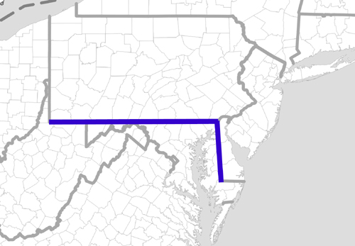
South Jersey don't enter into it!! :-) Some are tempted to extend the PA/MD line across other states and consider it a line between where slavery existed and where it didn't, (some call this idea the "colloquial" Mason-Dixon Line). This is not accurate: there was a significant amount of slavery north of N 39º 43' through the early decades of the 1800s. The latitude line N 39º 43' does pass through New Jersey just as it does through West Virginia, Ohio, Indiana, Illinois, Missouri, Kansas, Colorado, Utah, Nevada, California, Japan, North Korea, China, Tibet, Kyrgyzstan, Tajikistan, Uzbekistan, Turkmenistan, Azerbaijan, Armenia, the Nakhchivan exclave of Azerbaijan, Iran, Turkey, Greece, Albania, Italy, Sardinia, Mallorca, Spain and Portugal! So it doesn't make much sense to try to extend one portion of the Mason-Dixon line beyond Maryland, to imagine that it had any bearing on where slavery existed, or even to try to identify where sympathy with the confederacy was stronger. During the run-up to the Civil War sympathy with the southern states was far stronger in North Jersey than it was in South Jersey. In fact, a strong case might be made, in regard to New Jersey, for a REVERSE Slavery-Line since through the early 1800s slavery was much more prevalent in North Jersey than it was in South Jersey. A contemporary map of "Northern/Southern States" in 1861 clearly identifies New Jersey in the North. Maryland and Delaware are identified in the South even though they were Union states in the war, probably because they did not have state laws abolishing slavery. 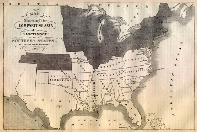
This site maintained by Bob Barnett. Last updated: 2007 Ninth Month, 8th. |